Como pensou
The user wants me to solve a UNICAMP 2027 multiple choice question. The image is rotated 90 degrees (text appears sideways). Let me read it.
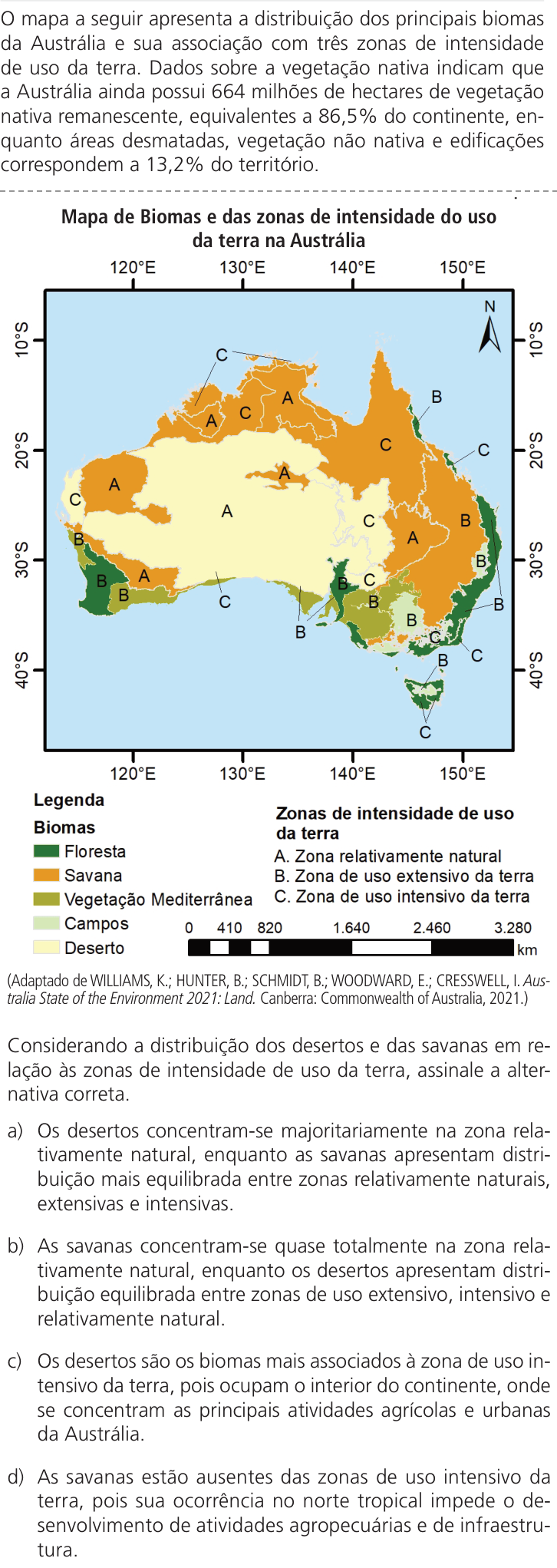
The image shows a map of biomes and land use intensity zones in Australia, with a legend:
- Biomas: Floresta, Savana, Vegetação Mediterrânea, Campos, Deserto
- Zonas de intensidade de uso da terra: A. Zona relativamente natural, B. Zona de uso extensivo da terra, C. Zona de uso intensivo da terra
Then there's text at the top: "O mapa a seguir apresenta a distribuição dos principais biomas da Austrália e sua associação com três zonas de intensidade de uso da terra. Dados sobre a vegetação nativa indicam que a Austrália ainda possui 64 milhões de hectares de vegetação nativa remanescente, equivalentes a 86,5% do continente, enquanto áreas desmatadas, vegetação não nativa e edificações correspondem a 13,2% do território."
Hmm, this seems odd. Actually wait, the text seems to be a mash of text. Let me re-read.
Actually, the text seems distorted/rearranged. Let me read carefully from the image description.
The top text: "O mapa a seguir apresenta a distribuição dos principais biomas da Austrália e sua associação com três zonas de intensidade de uso da terra. Dados sobre a vegetação nativa indicam que a Austrália ainda possui 64 milhões de hectares de vegetação nativa remanescente, equivalentes a 86,5% do continente, enquanto áreas desmatadas, vegetação não nativa e edificações correspondem a 13,2% do território."
Hmm, but that doesn't quite make sense with 64 million hectares = 86.5% of the continent. Australia is ~769 million hectares. 64 million is only 8.3%. So maybe the numbers are scrambled. Actually the question probably has scrambled numbers as a trick? Hmm.
Wait — actually this is a UNICAMP 2027 question. But UNICAMP 2027? That's future. Anyway.
Hmm, actually the text seems garbled. Let me reconsider: This might be an artificially generated/garbled image. But let me work with what's given.
Actually, I think there might be something suspicious: the text at the top repeats "da Austrália" many times and has percentages. The question is multiple choice a) b) c) d).
Let me read the options:
a) Os desertos concentram-se majoritariamente na zona relativamente natural, enquanto as savanas apresentam distribuição mais equilibrada entre zonas relativamente naturais, extensivas e intensivas.
Hmm, let me re-read option a:
"a) Os desertos concentram-se majoritariamente na zona relativamente natural, enquanto as savanas apresentam distribuição mais equilibrada entre zonas relativamente naturais, extensivas e intensivas." — Something like that. The OCR is garbled: "Os desertos concentram-se majoritariamente na zona relativamente natural, enquanto as savanas apresentam distribuição mais equilibrada entre zonas relativamente naturais, extensivas e intensivas."
Actually the OCR text: "a) Os desertos concentram-se majoritariamente na zona relativamente natural, enquanto as savanas apresentam distribuição mais equilibrada entre zonas relativamente naturais, extensivas e intensivas."
Hmm, the OCR: "a) Os desertos concentram-se majoritariamente na zona relativamente natural, enquanto as savanas apresentam distribuição mais equilibrada entre zonas relativamente naturais, extensivas e intensivas."
b) As savanas concentram-se quase totalmente na zona relativamente natural, enquanto os desertos apresentam distribuição equilibrada entre zonas de uso extensivo, intensivo e relativamente natural.
c) Os desertos são os biomas mais associados à zona de uso intensivo da terra, pois ocupam o interior do continente, onde se concentram as principais atividades agrícolas e urbanas da Austrália.
d) As savanas estão ausentes das zonas de uso intensivo da terra, pois sua ocorrência no norte tropical impede o desenvolvimento de atividades agropecuárias e de infraestrutura.
So the question: based on the map, which statement is correct?
Need to analyze the map: Australia biomes map with letters A, B, C indicating land use intensity zones.
Legend: Biomas: Floresta (dark green), Savana (medium green), Vegetação Mediterrânea (light green?), Campos (pale yellow-green), Deserto (yellow/cream).
Zones: A = relatively natural, B = extensive use, C = intensive use.
Looking at the map: The interior (large yellow/cream area = desert) is mostly labeled A. The northern and eastern coastal areas (green = savanna/forest) are labeled B and C. The southwest and southeast corners (mediterranean vegetation) labeled B and C. There are some C labels in the north and along the east coast.
Let me look at labels: In the desert central region: A's. In the north (savanna region): C's appear. In the northeast: B, C. In the east coast: C, B. In the southwest: B, C. In the southeast: C, B.
So deserts are mostly in zone A (relatively natural). Savannas have a mix: A in some places (central-north?), B, C.
Hmm, actually looking at the map: there are "C" letters in the northern savanna region, and "A" and "C" in the middle-north. The savanna (medium green) covers the north and east. In the north there are C's (intensive use?) Hmm.
Wait, the map shows labels. Let me try to place them from the image:
Top area (north): "C" appears at around 130°E, 15°S area (north-central). Also "A", "C" in the northwest. "B" in the northeast.
Middle: "A" in the desert center, "C" in the east, "A" east-center, "B" far east.
Southwest: "C", "B", "A".
South: "C", "B", "C", "B", "C".
Southeast: "B", "C", "B", "C".
So the desert region is dominated by "A" (relatively natural). The savanna region in the north has C's and A's, B's.
Given the options:
a) Deserts concentrated in relatively natural zone; savannas more balanced distribution among natural, extensive, intensive. This seems plausible: desert = A mostly, savanna = A, B, C mix.
b) Savannas almost totally in relatively natural zone; deserts balanced among extensive, intensive, relatively natural. This seems wrong — deserts appear mostly in A.
c) Deserts are most associated with intensive use zone — wrong, deserts are interior, not intensive agriculture.
d) Savannas absent from intensive use zones — wrong, C's appear in savanna region.
So answer likely (a).
But wait, I need to verify: In the map, do deserts have only A? The desert (yellow) covers the center and west. Labels there: A (center), C (west-central? there's a "C" at around 125°E, 30°S in the yellow region?), Let me check: "C" appears at left around 30°S in the map ("C" at west). Hmm.
Actually the map: at around 115-120°E, 30°S there's "B" and "C" labels in the southwest (mediterranean vegetation region). The desert region: labels "A" in the center (around 130°E, 25°S), "A" at 135°E, 20°S.
Hmm, there's also "C" in the middle-north at ~133°E, 20°S inside the desert? Actually let's look again: the letters listed in the image: C (top left ~127°E,18°S), A (132°E, 18°S), C (138°E, 18°S), B (148°E, 15°S)... Hmm hard.
The garbled text at top mentions "86,5%" and "13,2%" — these might be distractors. Also "64 milhões de hectares".
Anyway, the conceptual answer: Australia's deserts are relatively natural (low human use), while the savannas in the north have been converted for extensive cattle ranching and some intensive use. So (a) is correct.
But let me double-check option (a)'s wording as OCR'd: "Os desertos concentram-se majoritariamente na zona relativamente natural, enquanto as savanas apresentam distribuição mais equilibrada entre zonas relativamente naturais, extensivas e intensivas."
Hmm, but is that consistent with the map? In the map, savanna areas: north has C? Actually intensive use in Australia is mainly along the east coast (sugarcane, horticulture) and southwest. The savanna in the north is used for extensive cattle grazing (B). Hmm.
But the map shows C in the northern savanna region, which is a bit odd, but the question is based on the map.
Given the map, deserts = mostly A; savannas = A, B, C mix. So (a).
Let me verify by examining the letter distribution more carefully based on the visual:
From the image, letters (approximate positions in the rotated image):
- "C" at top-left of the continent (~127°E, 18°S)
- "A" at (~133°E, 17°S)
- "C" at (~140°E, 17°S)
- "B" at (~147°E, 14°S)
- "A" at (~122°E, 22°S)? there's "A" at left-center
- "C" at (~117°E, 30°S) west
- "B" at (~115°E, 33°S) southwest
- "A" at (~120°E, 30°S)?
- "A" at (~131°E, 25°S) center desert
- "A" at (~140°E, 25°S)?
- "B" at (~152°E, 30°S) east coast
- "C" at (~150°E, 27°S)
- "B" at (~140°E, 33°S)
- "C" at (~127°E, 33°S)
- "B" at (~135°E, 33°S)
- "C" at (~140°E, 37°S)
- "B" at (~145°E, 37°S)
- "C" at (~147°E, 40°S) Tasmania
So desert region: A's dominate (center, west-center). Savanna region (north): C, A, C, B. So savanna has a mix: C, A, B. And desert has A plus maybe a C in the west.
Option (a) says deserts concentrated in relatively natural zone; savannas distributed among natural, extensive, intensive. That matches.
Option (b) says savannas almost totally in natural zone, deserts balanced among extensive, intensive, natural — contradicts.
So answer A.
But hold on — the question text mentions "Dados sobre a vegetação nativa indicam que a Austrália ainda possui 64 milhões de hectares de vegetação nativa remanescente, equivalentes a 86,5%..." Hmm, this is weird. Actually maybe the text is: "Dados sobre a cobertura vegetal nativa indicam que a Austrália ainda possui 64 milhões de hectares..." Hmm, actually 64 million ha might be the area of native vegetation remaining in one zone? Or maybe it's a garbled text.
Actually, wait. Perhaps the original question was about Brazil (UNICAMP is Brazilian) — the garbled text mentions "86,5% do continente". Hmm.
Regardless, the question asks based on the map. Let's answer (a).
Hmm, but let me reconsider: the garbled top text says "equivalentes a 86,5% do continente" for 64 million ha — that's inconsistent. Possibly the actual text: "a Austrália ainda possui 164 milhões de hectares de vegetação nativa remanescente, equivalentes a 86,5%..." Hmm 164/769 = 21%. Hmm no. Actually 86.5% of 769 Mha = 665 Mha. Hmm.
Maybe the text is intentionally mangled (the image seems to have garbled text with repeated words). This is a synthetic image. The letters might also be randomly placed... but let's go with the analysis.
Given the repeated text pattern in the options ("a zona relativamente natural", etc.), it's plausible the answer is (a).
Let me think about the geography knowledge: In Australia, deserts (central) are largely intact/natural (zone A). Savannas (north) are used extensively for cattle grazing (zone B) but also have some intensive uses (zone C) — actually the map shows C in the north? Hmm, the intensive zones in Australia are mainly in the southeast and southwest (wheat-sheep belt, cities) — which correspond to mediterranean vegetation and temperate forests, not savanna. But the map given shows C in the northern savanna region.
Hmm, but given the map has C labels in the north (around 130-140°E, 15-20°S), which is savanna region, option (a) fits.
Alternatively, option (b) says savannas almost totally in relatively natural zone — but the map shows C's and B's in the savanna, so no.
I'll answer (a).
Wait, but let me double check the option (a) text: "Os desertos concentram-se majoritariamente na zona relativamente natural, enquanto as savanas apresentam distribuição mais equilibrada entre zonas relativamente naturais, extensivas e intensivas."
Hmm, in the map, savanna region: north has C (intensive), A (natural), B (extensive) — yes balanced-ish. Desert: A mostly. Good.
So answer: A.
Now write explanation in Portuguese.
I should mention: The central desert region is largely covered by zone A (relatively natural), since those areas are sparsely populated and of little agricultural use. The savanna belt in the north/northeast includes zones A, B and C — from natural areas to extensive cattle ranching and intensive use (agriculture, urban). Therefore letter A.
Let me also refute b, c, d briefly.
Terminate with "Resposta: A".
Note: the options in the image are labeled a) b) c) d) but the answer format asks for A, B, C, D. So "Resposta: A".
Let me write the response.